
:strip_icc()/i.s3.glbimg.com/v1/AUTH_cf9d035bf26b4646b105bd958f32089d/internal_photos/bs/2024/V/B/OB9rpAQZ21RtkRUrvXgA/youtube-thumbs-poer.jpg)

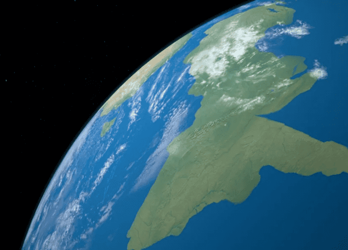
Zealandia is the first continent to be completely mapped by researchers. Zealandia has only been recognized as a continent since 2017, and remains a mystery. Completing this work could allow science to learn more about the region, much of which is submerged in the ocean.
Read more
New Zealand
- Zealandia has an area of about 4.9 million square kilometres, and includes the islands of New Zealand and New Caledonia.
- Its area is larger than India and Greenland, but most of it is submerged in the ocean.
- Since the 19th century, there have been speculations about the existence of a huge continental shelf beneath New Zealand, but attempts to find it did not begin until after the United Nations Convention on the Law of the Sea came into force.
- This agreement allows countries to claim exploration of territory outside the exclusive economic zone, as long as it is located on their continental shelf.
- Much about this new continent is still a mystery. What we do know is that it belongs to the supercontinent Gondwana, having separated about 85 million years ago.
- Researchers cannot determine whether it ever appeared above the surface of the sea, and if so, the question remains as to what could be living there.
Discoveries of scientists
Based on an article published in 2019, an international team of scientists successfully completed mapping the continent. According to the study, “New Zealand is the first among Earth's continents to have its bottoms, sedimentary basins and volcanic rocks completely demarcated by continent-ocean boundaries.”
Previous research has determined that Zealandia's crust is thinner than that of most other continents. Using magnetic surveys, this new study discovered basalt lava rocks, indicating the presence of a giant volcanic zone at the site.
It is believed that there was significant volcanic activity on the continent between 100 and 60 million years ago, around the time Zealandia separated from Gondwana. According to scientists, molten magma has flooded cracks and fissures for at least 40 million years.
Through dating and chemical analysis, the completed map also revealed a picture of another key part of Zealandia's history – the four-thousand kilometre-long granite spine. The transcontinental granite belt, nicknamed the Median Batholith, is thought to be between 250 and 100 million years old.
Although the continent is the first to be fully mapped, there are still many uncertainties about Zealandia and new research is needed to try to understand what really happened to the region. The study was published in the journal Tectonics. The information is from IFLScience.

“Hardcore beer fanatic. Falls down a lot. Professional coffee fan. Music ninja.”
More Stories
What is the ideal running time to lose belly fat?
With science and dialogue, Otinga State Park celebrates 31 years
Money Dose: The Science Behind the ‘No’ That Doesn’t Come Out Why is Saying No So Hard?