


Strong winds have wreaked havoc in southern Uruguay due to the severe tropical cyclone currently operating in the southern Atlantic Ocean. The Uruguayan province most affected by the strong winds, MetSul warned, is Maldonado. Punta del Este is the city most affected by the winds.
❗️ ▶ ️ # Punta deleste Strong winds caused trees to fall at some coastal points spurring the work of the Maldonado Bomber Detachment, IDM, UTE Urban Assets and Environmental Management teams due to fallen trees, electrical cable cuts… pic.twitter.com/QUXaGhbygT
– Marcelo Ombrez 📞099323625 (@emekavoces) August 20, 2023
According to journalist Marcelo Amprez, from Punta del Este, fire brigades from Maldonado County have so far responded to dozens of wind-related incidents.
Disturbances and damage in Maldonado, particularly in Punta del Este, include downed trees, broken power cables, and rooftops. Tiles were scattered in some of the city streets. The wind also overturned containers used to collect household waste.
According to the real-time monitoring by the Uruguayan electricity company UTE, the blackouts were not large and were more concentrated in the departments of Rocha and Maldonado.
The entire Saturday was windy in southern Uruguay with the most intense storms in Maldonado Province. Laguna del Sauce Airport recorded gusts of 37 knots (69 km/h), but winds were strongest in Punta del Este.
In Montevideo, a special automatic station recorded wind gusts of 80.5 km/h at 3:40 pm near the Prado, in Bella Vista. In Piriapolis, Maldonado, another private station reported winds of 63 km/h.
In Argentina, the hurricane also caused damage. As expected, the problems were caused by strong winds on the coast of Buenos Aires Province. Dozens of trees fell with the strong winds in separate areas of Mar del Plata, in addition to posters and umbrellas that flew in the air due to wind gusts that sometimes exceeded 80 km / h.
The strong winds of recent days have generated different attitudes in the city. As always, the civil defense teams work together with the different regions on the first line to respond to possibilities that may endanger the vecinos … pic.twitter.com/d2svvpxtPN
– Guillermo Montenegro (@gmontenegro_ok) August 19, 2023
According to what was determined by the Civil Defense, the most complex incident occurred in the Boque Peralta Ramos neighborhood, where a tree fell on a house, causing material damage. The operators had to cut it because the station also cut a street and affected the power grid.
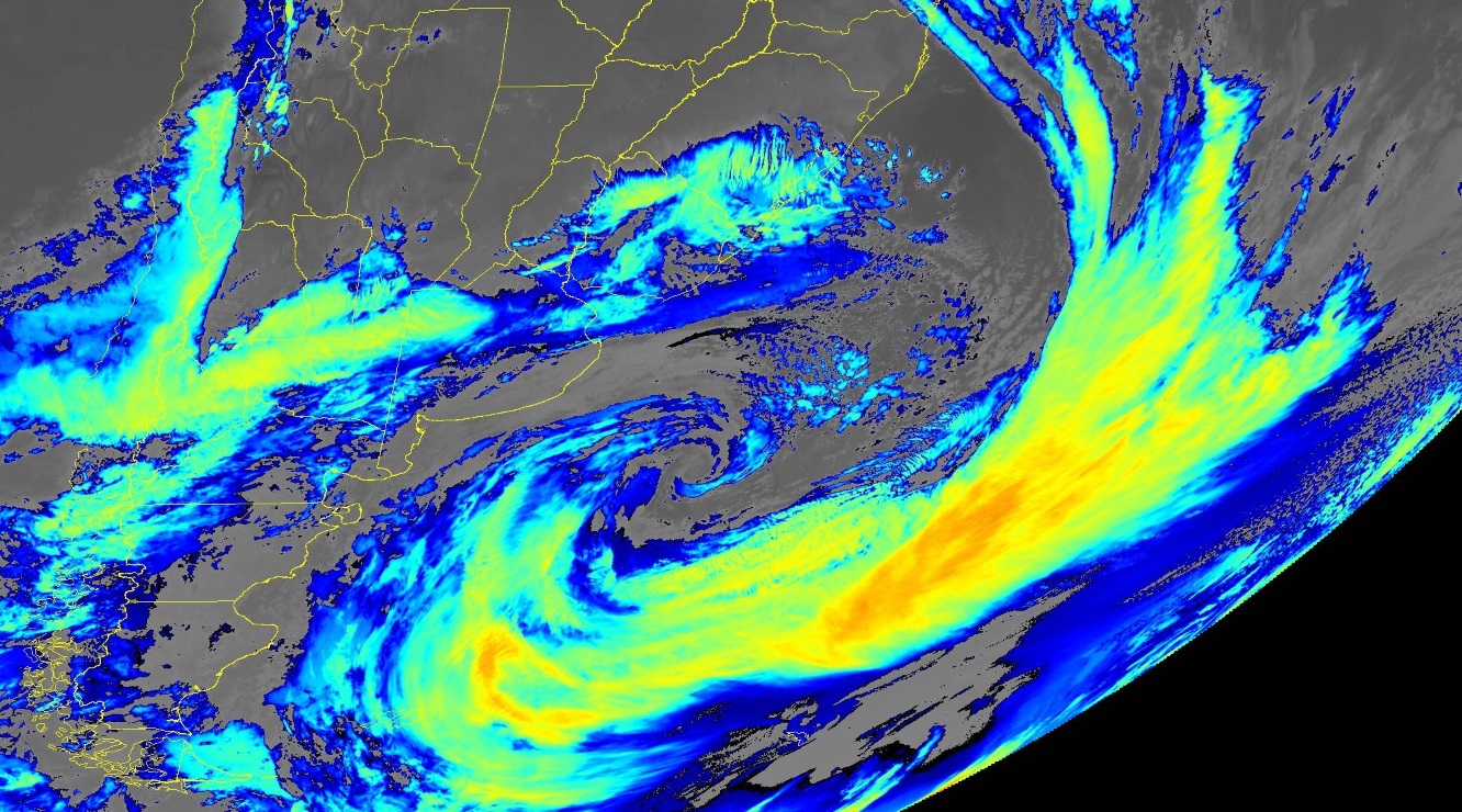
Satellite image of the hurricane over the South Atlantic Ocean Saturday night | NOAA
This Sunday, the extratropical cyclone will remain nearly stationary over the South Atlantic Ocean at coordinates 42°C and 50°C with great intensity, presenting a minimum central atmospheric pressure of 975 hPa and therefore an intensifying system over the sea.
On Monday, the extratropical cyclone will move and weaken as a decrease in atmospheric pressure difference is expected with the formation of a second hurricane that will operate along the coast of Patagonia.

“Music fanatic. Professional problem solver. Reader. Award-winning tv ninja.”
More Stories
Learn which foods you should avoid and protect your health
The European Union reaches a preliminary agreement to use frozen Russian profits
Why are nearly half of China’s major cities flooded?